
Professional Geomatics Drone Simulator: Realistic Training for Precision Surveying and Mapping
2026-09-17
Most drone surveying courses teach you what buttons to press. They don’t teach you what to do when a gust hits mid-transect or your video link drops over a construction site. SRIZFLY’s professional geomatics drone simulator builds that judgment by forcing you to fly realistic missions for precision surveying and mapping—without the six-figure repair bill. Here’s why that kind of training changes how your team performs in the field.
From Simulated Flight Lines to Centimeter-Level Accuracy
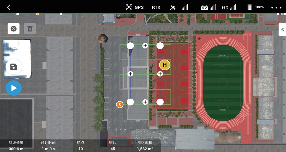
Simulated flight lines are more than a preview of where the drone will travel. They encode the side overlap, altitude, camera trigger spacing, and terrain-following behavior that determine whether the final point cloud will hold together or fall apart at the edges. A well-designed simulation lets you spot gaps in coverage before the aircraft leaves the ground, especially over rolling terrain or along narrow corridors where a fixed-altitude grid would otherwise leave holes in the model.
When the mission moves from the planning screen to the actual flight, the same parameters need to survive contact with wind, barometric drift, and slight deviations in the drone's path. This is where centimeter-level accuracy gets built or lost. Using RTK or PPK positioning, combined with checkpoints placed outside the area of interest, keeps the reconstructed surface locked to a known coordinate frame instead of drifting with the drone's onboard GPS.
The final step is tighter than most people expect: even a few degrees of camera tilt or a small change in overlap can push errors from the centimeter range into the decimeter range. By comparing the simulated flight lines against the actual image positions after processing, you can catch those inconsistencies early and re-fly only the affected strips rather than the entire site. That loop between simulation and verification is what turns a promising plan into repeatable, survey-grade results.
Modeling Real-World Sensors Without Leaving the Ground
When an autonomous vehicle team wants to test how a lidar behaves in fog or how an IMU drifts over a long mission, sending hardware into the sky or onto a closed track is often impractical. A ground-based sensor modeling setup can reproduce much of that behavior by combining physics-based simulations with recorded field data. The key is to treat each sensor not as a perfect data source but as a system with its own noise floor, latency, field-of-view limitations, and occasional dropouts. By tuning these parameters against a few hours of real sensor logs, the model can generate synthetic streams that push the perception stack into edge cases without ever moving the vehicle.
One effective approach is to build a hybrid model that mixes deterministic physics with stochastic error injection. For example, a camera model can start with a renderer that respects lens distortion and exposure, then overlay shot noise, blooming artifacts, and motion blur based on the platform’s actual vibration profile. Similarly, a radar model can simulate multipath reflections by convolving the scene geometry with a measured antenna pattern. Because the error statistics are captured from bench tests, the ground-based model remains faithful to the quirks of the specific hardware unit, not just a generic datasheet.
Maintaining a feedback loop between simulation and recorded data matters more than chasing perfect fidelity. When a perception algorithm fails on synthetic data, the failure should be traced back to a sensor parameter that can be measured in the lab, such as a delayed IMU timestamp or a GPS multipath envelope. This lets engineers adjust the model with a quick bench measurement instead of waiting for the next flight window. Over time, the sensor model becomes a living artifact that captures how the hardware actually behaves in the field, even though it was built and refined entirely on the ground.
Training Missions That Mirror Field Conditions
Field conditions rarely follow a script, so our training missions are built around unpredictability. Instead of rehearsing static drills, teams navigate shifting terrain, sudden weather changes, and equipment failures that mirror real operational friction. The goal is not to memorize a response, but to develop the situational awareness needed when plans fall apart.
We design scenarios using data from actual field reports, then inject variables that force quick judgment calls. Operators practice communication under stress, resource rationing, and improvised problem-solving with limited intel. Every exercise ends with a debrief that compares decisions against ground truth, turning mistakes into repeatable lessons.
The result is a force that doesn't just survive the unexpected—it adjusts, coordinates, and pushes forward. Leadership emerges under pressure, and habits form that translate directly to live missions. When the training environment feels chaotic, the real thing feels familiar.
Building Confidence in Complex Terrain Before Takeoff
Complex terrain demands more than just technical skill—it asks for a quiet certainty in your own decisions. Before lining up for takeoff, walk the ground if you can. Feel the slope, note the rocks and soft patches, and let each detail anchor your mental picture. When you return to the controls, that familiarity becomes a steady inner voice, not a checklist shouting at you.
Rehearse the departure in slow motion. Picture the aircraft lifting, the wing clearing the ridge, the climb gradient holding in gusty air. This is not daydreaming; it is priming your reactions. Run through what you will do if the wind shifts ten degrees or the ground drops away sooner than expected. Confidence grows when your body already knows the path your mind has walked.
Finally, set a personal minimum and stick to it—not as a restriction, but as a promise to yourself. If the terrain feels doubtful or the light is tricky, waiting is not weakness. Real confidence includes knowing when to say not yet. Each safe decision, made early and without drama, builds a foundation that no landing strip can give you.
Turning Simulation Hours into Survey-Grade Results
Turning raw simulation hours into survey-grade results is less about software magic and more about tightening the loop between what's modeled and what's measured. The first shift happens when every hour logged in a simulated environment gets treated as a candidate for real-world accuracy, not just a training tally. That means running the same checks surveyors rely on: overlapping coverage, visible ground control, repeat passes over high-risk edges, and honest residuals after adjustment. Once those checks become part of the simulation routine, the jump to accepted deliverables stops feeling like a separate phase.
A practical approach is to let the simulation expose weak spots before field crews ever leave the office. For example, if a simulated corridor consistently loses tie points under certain lighting or vegetation density, that pattern gets flagged and repaired in the planning stage. The result isn't a promise of perfection but a tighter distribution of errors that survives scrutiny. Teams that treat simulation hours as a rehearsal for measurement, not a substitute for it, end up with data that can hold its own against traditional control networks.
A Virtual Lab for Every Stage of the Mapping Workflow
Setting up a mapping project usually means juggling separate tools for field collection, data cleaning, symbolization, and layout. A virtual lab removes those breaks. You can move from raw GPS tracks and survey notes straight into a shared workspace where topology checks, attribute joins, and scale-dependent styling happen side by side. The environment keeps every step versioned, so a bad coordinate system choice or an over-aggressive simplification doesn't force you to rebuild the whole project.
Because each stage of the mapping workflow has different demands, the lab adapts rather than forcing one rigid pipeline. Field teams might upload batches of geotagged photos and voice memos; analysts then run conflation routines against existing road networks or cadastral parcels. Cartographers can test label placement and color ramps on live data without waiting for a separate export. The result is less time spent packaging files and more time actually improving the map.
Collaboration also stops being a bottleneck. Reviewers can leave comments directly on features, compare two versions of a disputed boundary, and roll back only the affected tiles. Automated validation flags gaps, overlaps, and invalid geometries early, while final layout templates apply consistent title blocks, legends, and scale bars. In short, the lab covers the whole arc from messy field input to print-ready or web-ready output without making you switch contexts.
FAQ
It goes beyond stick time. You're working with terrain models, LiDAR simulation, photogrammetry workflows, and control point placement—basically the whole survey pipeline from flight planning to data export, not just the airborne part.
The simulator reproduces wind gusts, battery sag, and even IMU drift. If you push too hard on a mapping mission, you'll see motion blur or gaps in coverage, which teaches you to respect the limits of the actual hardware.
Yes, you can import DEMs and orthophotos to build a virtual copy of a project area. It also lets you swap between different payloads—RGB, multispectral, or LiDAR—so the training matches the gear you'll actually fly.
Both. New pilots learn workflow fundamentals without risking equipment. Experienced crews use it to rehearse tricky corridor mapping, tight airspace, or night operations, and to test flight plans before arrival on site.
The simulation walks you through generating point clouds, DSMs, DTMs, and orthomosaics. You can even introduce systematic errors to see how they degrade the final product and learn to spot them.
It integrates with common photogrammetry and GIS packages, so you can push simulated captures through the same processing stack you'd use on a job. That closes the gap between practice and production.
Instead of simple pass/fail tests, it tracks mission efficiency, overlap consistency, RTK fix stability, and battery management. You get a detailed debrief showing where your flight plan deviated from best practices.
Generic simulators focus on stick-and-rudder skills or racing. This one is built specifically for geomatics—every visual detail, from the way shadows fall on a construction site to the GCP placement constraints, is tied to surveying accuracy.
Conclusion
A geomatics drone simulator that actually mirrors field sensor behavior changes how surveyors prepare for real missions. Instead of learning on expensive hardware or waiting for clear skies, crews can rehearse flight lines over a digital twin of the project area, adjusting altitude, overlap, and speed while watching how these choices affect point density and accuracy estimates. The simulator models real-world sensor characteristics—GNSS noise, IMU drift, camera distortion, LiDAR returns—so operators develop a feel for what centimeter-level data requires before they ever leave the ground. Training missions pull from actual terrain models, including steep slopes, vegetation, and narrow corridors, pushing pilots to plan routes that would be risky or impossible to practice on a live site.
The real value comes from translating every simulated hour into survey-grade workflow habits. From mission planning and equipment checks to in-flight problem solving and post-processing checks, the virtual lab covers the full mapping pipeline. Operators can repeat difficult scenarios until confident: a tight corridor between buildings, a sudden wind shift, a battery warning mid-transect. That repetition builds judgment, not just stick time—knowing when a flight plan needs one more cross-line, or when sensor settings will produce clean data under variable light. By the time a crew arrives on site, they have already tested the decisions that matter, turning simulation practice into reliable field results.
Contact Us
Contact Person: Niles Liu
Email: [email protected]
Tel/WhatsApp: 8619945009803
Website: https://srizfly.com/